Geography
Index
- Climatology
- Forest Resources
- Geomorphology
- Important Geophysical Phenomena such as earthquakes, Tsunami, Volcanic activity, cyclone
- Oceanography
- Physical Geography of India
- Soil Geography
Role of Geographical Factors in Shaping Ancient History
- Role of geographical factors in shaping Ancient History
- Indus and Ganges River Systems : facilitated growth of early civilizations like the HARAPPAN and VEDIC societies.
- IVC cities like MOHENJO-DARO and HARAPPA.
- Fertile Soils : supported extensive agriculture leading to surplus production
- Example: The MAURYAN EMPIRE, with its capital at PATALIPUTRA, flourished.
- The HIMALAYA : acted as natural barrier protecting from invasions and ensuring political stability
- DECCAN PLATEAU : provided rich mineral resources and arable land for southern kingdoms
- Monsoon winds provided reliable rainfall for agriculture
- Extensive coastlines enabled the development of ports and trade networks
- LOTHAL used for trade between IVC with MESOPOTAMIA
- MUZIRIS for trade with ROMANS
- Mountain passes : facilitated trade and cultural exchanges
- The SILK ROAD connected India with world
- Indus and Ganges River Systems : facilitated growth of early civilizations like the HARAPPAN and VEDIC societies.
Salient features of World’s Physical Geography
- What make fjords picturesque
- Dramatic landscape : stark contrast between steep cliffs and fjords create awe and grandeur.
- Crystal clear water
- Waterfalls
- Lush vegetation
- Support diverse ecosystems and abundant wildlife
- Recreational activities like kayaking, hiking and cruising
Geomorphology
- Origin & Evolution of Earth
- Interior of the Earth
- lithosphere - SiAl - Acidic
- Asthenosphere - SiMg - Basic - partially molten
- Distribution of Continents & Oceans
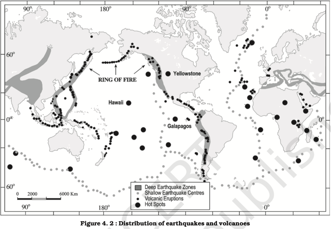
- Geophysical characteristics of Circum-Pacific Zone
- Tectonic Plate Boundaries
- Subduction Zones
- CASCADIA subduction zone NORTH AMERICA
- Convergent
- MARIANA TRENCH
- Divergence
- EAST PACIFIC RISE
- Transform Boundaries
- SAN ANDREAS FAULT
- Volcanism
- 75% volcanos
- Earthquakes
- Tsunamigenic region
- Mountain Ranges
- Island Arcs
- Geothermal Activity
- Region of dynamic geological activities making it one of the most fascinating as well as hazardous areas of earth.
- Subduction Zones
- Tectonic Plate Boundaries
- Geophysical characteristics of Circum-Pacific Zone
- Continental drift theory, 1912
- ALFRED WEGNER
- Evidence
- Jig-Saw Fit
- The eastern coast of South America and the western coast of Africa
- Placer deposits
- Fossil evidence
- MESOSAURUS fossils discovered on both South America and Africa
- Tillites
- Glacial deposits in India - TALCHER formation
- Rocks on different continents
- E.g. DHARWAR rocks extension to Africa
- Jig-Saw Fit
- Convectional current theory
- ARTHUR HOLMES
- Due to presence of radioactive material in mantle
- Seafloor spreading theory
- HARRY HESS
- Plate Tectonic Theory
- MCKENZIE, PARKER, MORGAN (1967)
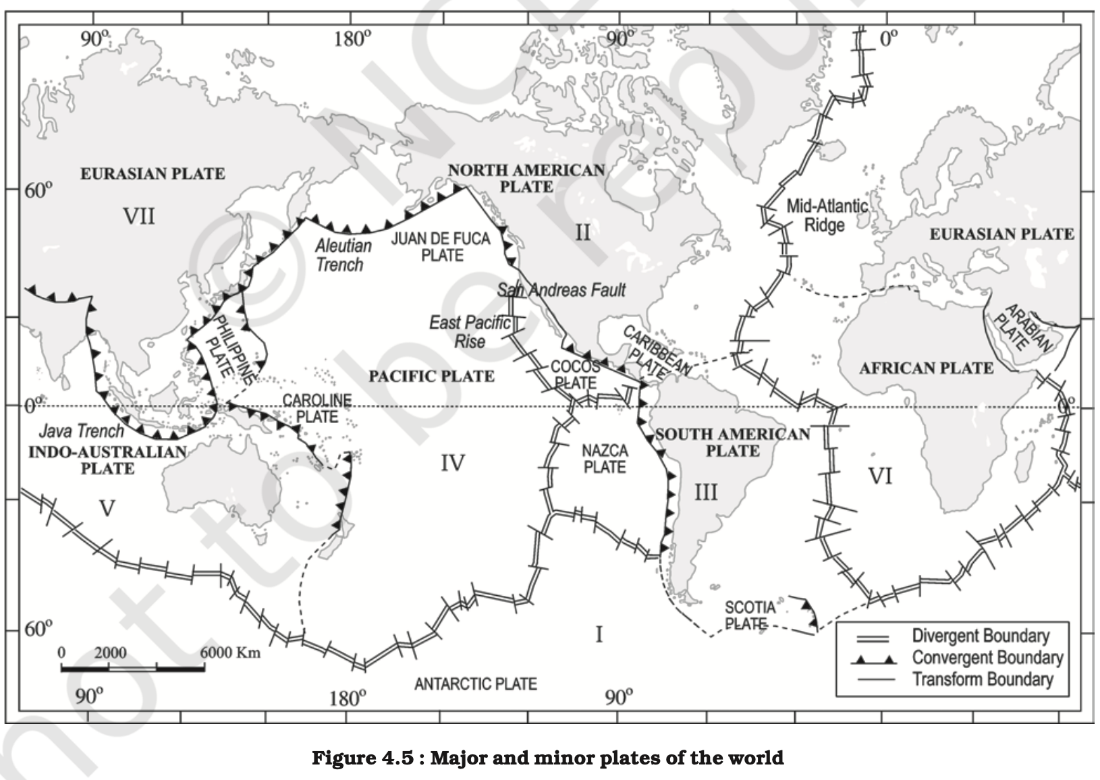
- Reasons for tectonic plate movement
- Heat released from the radioactive decay
- Ridge Push - along the mid-oceanic ridge
- Slab Pull - along the trenches
- Boundaries
- Divergent Boundary
- Ocean - Mid Oceanic Ridges
- E.g. MID ATLANTIC
- Land - Rift Valleys
- E.g. AFRICAN RIFT VALLEY
- Ocean - Mid Oceanic Ridges
- Convergent Boundary
- Ocean - Trenches
- MARIANA TRENCH
- Land - Fold Mountains
- E.g. ANDES, ROCKIES mountain(O-C)
- E.g. TIBETAN PLATEAU, HIMALAYAN mountains (C-C)
- Ocean - Trenches
- Transform Boundary
- E.g. SAN ANDREAS FAULT (O-C)
- E.g. along MOR (O-O)
- Divergent Boundary
- Major mountain ranges
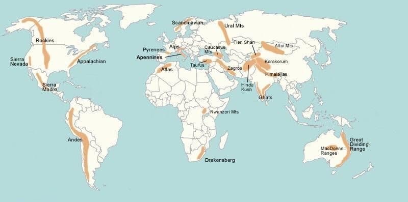
- List
- HIMALAYAN:
- ROCKY MOUNTAINS:
- ANDES
- ALPS
- URALS
- GREAT DIVIDING RANGE:
- Impacts
- Blocking Winds : HIMALAYAS block cold, dry winds from Central Asia
- Orographic Rainfall: precipitation on the windward side
- Rain Shadow Effect : on the leeward side (opposite the wind)
- Mountains can redirect wind flow creating unique patterns
- Distribution of Earthquakes & Volcanoes
- Magma -
- lithosphere melted magma - less dense, less fluid, solidify fast, light and acidic, Andesitic magma.
- E.g. MOUNT KILIMANJARO, MOUNT MERU (Stratovolcano)
- E.g. Ridges and seamounts
- Mantle Plume(Hotspot) Magma - less basic, formed due to variation in density and mineral composition, MgFe
- Shield volcanos domes
- E.g. MAUNA LOA, HAWAII
- REUNION islands
- Fissure Basalt Plateau (land)
- DECCAN traps
- Seamount Chains : EMPEROR SEAMOUNTS
- Shield volcanos domes
- Asthenosphere rising magma - basaltic, MOR, Abyssal plane
- lithosphere melted magma - less dense, less fluid, solidify fast, light and acidic, Andesitic magma.
- Volcanos
- Intrusive | underground volcano
- Horizontal
- Sills, Laccolith , Batholith
- Vertical
- Dykes
- Geysers and Hot springs
- E.g. YELLOWSTONE US
- Horizontal
- Extrusive | Surface volcano
- Active | Dormant | Extinct
- Shield volcano
- E.g. MAUNA LOA, HAWAII
- Cinder volcano
- E.g. MOUNT ETNA, ITALY
- PARÍCUTIN in MEXICO
- Strato volcano
- E.g. KILIMANJARO, TANZANIA
- SEMERU, INDONESIA
- Caldera
- E.g. KILAUEA, HAWAII
- MOUNT MAZAMA USA
- Impact on regional environment
- Air pollution
- Disruption to agriculture
- Landslides and mudflows
- Contaminate water resources
- Disrupt transportation and infrastructure
- Measures
- Monitoring - Seismic monitoring and early warning system
- Preparedness - Hazard mapping and land use planning accordingly
- Mitigation - evacuation plans and training local communities
- Response - lava flow diversion, health and safety measures
- Intrusive | underground volcano
- Earthquakes
- Types
- Shallow focus < 70km
- Intermediate focus 70-300 km
- Deep focus > 300km
- Waves
- Body waves
- P waves
- S waves
- Surface waves
- Rayleigh waves
- Love waves
- Body waves
- Causes
- Natural - plate movement, mantle plume activities, volcanic activities, meteorites
- Anthropogenic - mining, construction, reservoir induced seismicity, nuclear explosion
- Measurement
- Intensity-based scale
- MERCALLI scale
- Amplitude based using seismograph measures magnitude
- RICHTER and moment-based scale
- MSK Scale
- Intensity-based scale
- Types
- Rocks & Rock Cycle
- Igneous Rocks(Primary rocks - because other rocks are formed from them) — solidified from magma and lava
- Characteristics
- Formation
- Texture - fine grain, coarse, glassy
- Mineral composition
- Colour
- Density
- Crystallization
- Optical properties - extinction angle, birefringence, biaxial symmetry
- Magnetic properties - diamagnetism, paramagnetism
- Types
- Plutonic rocks - solidified beneath the Earth’s surface.
- Volcanic rocks - solidified above the Earth’s surface.
- Examples - Granite, gabbro, pegmatite, basalt, volcanic breccia and tuff.
- Characteristics
- Sedimentary Rocks — the result of deposition of fragments of rocks by exogenous processes
- _lithification - “_denudational agents -> exogenous agencies -> deposited”
- Examples
- mechanically formed — sandstone, conglomerate, shale.
- organically formed — chalk, coal.
- chemically formed — limestone, potash.
- Metamorphic Rocks — formed out of existing rocks undergoing recrystallisation.
- Dynamic - without any appreciable chemical changes
- Thermal - chemically alter and recrystallise
- Contact - hot intruding magma
- Regional - tectonic shearing
- Example - gneiss, slate, marble, quartzite etc.
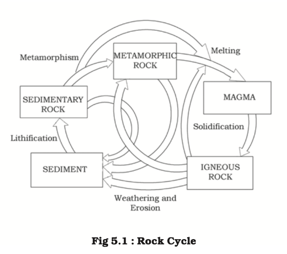
- MMISS
- Igneous Rocks(Primary rocks - because other rocks are formed from them) — solidified from magma and lava
- Geomorphic Processes –
- Endogenic -
- Sudden catastrophic forces and slow Diastrophic forces.
- Catastrophic
- Earthquakes
- Volcanism (process of volcanic activity) - formation of volcanoes (landforms)
- Diastrophic
- Vertical forces (Epeirogenic forces) - Uplifting or subsiding . - mainland uplifting - continental building
- Horizontal forces (orogenic forces) - compressing and tensing. - mountain building
- Folding
- Faulting
- Exogenic
- Gradation - The process of levelling the region.
- Degradation
- Aggradation
- Process of gradation - denudation. - WEMDT
- Weathering - breaking at the location. (in-situ).
- Physical - pressure (loading, unloading), temperature (freezing, thawing)
- Chemical - oxidation, reduction, solution
- Biological
- Erosion - Breaking of material due to friction is called erosion.
- Abrasion, Attrition, Corrosion, Hydraulic action, Plucking, Deflation
- Mass movement - Moving broken material down the slope using gravity.
- Slow - creep, solifluction
- Fast - slumping, landslides, mudflow, debris avalanche
- Deposition
- Weathering - breaking at the location. (in-situ).
- Transportation - by agents - (rivers, glaciers, winds, waves, ground water)
- Gradation - The process of levelling the region.
- Endogenic -
- Landforms & their Evolution
- Fluvial (river)
- Erosional
- Rills -> Gullies -> Valleys(V, Gorge, Canyon), Waterfalls, entrenched meanders
- Depositional landforms.
- alluvial fans, flood planes, natural levees, point bars, oxbow lakes, meanders, delta
- Erosional
- Aeolian (wind) through deflation, abrasion and impact
- Erosional
- Pediments and Pediplain, Playas, Deflation Hollows and Caves, Mushroom, Table and Pedestal Rocks
- Depositional landforms
- Sand Dunes - Barchans, Transverse, Linear, Parabolic
- Erosional
- Glacial (Movement of icesheets down the valley due to gravity)
- Erosional
- Cirque, Horns, Serrated Ridges, Glacial Valleys
- Depositional landforms.
- Moraines, Eskers, Outwash Plains, Drumlins
- Erosional
- Coastal waves
- Erosional
- Submerging landwards coasts (high, rocky coasts) (West coast)
- Sea Cliff, wave cut platform, Caves and Stacks, Fjords
- Depositional landforms
- Emerging seawards coasts (low, smooth, gentle sloping sedimentary coasts)
- Beaches and Dunes, Bars, Barriers and Spits.
- Erosional
- Karst (limestones or dolomites rich in calcium carbonate through solution and precipitation)
- Erosional
- Pools, Sinkholes (solution or collapse), Lapies and Limestone Pavements, valley sinks (uvalas), caves
- Depositional landforms
- Stalactites, Stalagmites and Pillars
- Erosional
- Fluvial (river)
- Geological Time Scale
Hydrology
- Hydrological Cycle
- Evaporation(latent heat of vaporisation), Transpiration, Condensation(hygroscopic condensation nuclei) and Precipitation.
- Condensation the water vapour - dew, frost (both on solid surface), fog, mist(more moisture then fog) and clouds.
- Clouds - (i) cirrus(8,000 - 12,000m, white, thin); (ii) cumulus(4,000 - 7,000 m); (iii) stratus; (iv) nimbus(black, near surface, think vapour).
- high clouds – cirrus, cirrostratus, cirrocumulus;
- middle clouds – altostratus and altocumulus;
- low clouds – stratocumulus and nimbostratus
- clouds with extensive vertical development – cumulus and cumulonimbus.
- Clouds - (i) cirrus(8,000 - 12,000m, white, thin); (ii) cumulus(4,000 - 7,000 m); (iii) stratus; (iv) nimbus(black, near surface, think vapour).
- Precipitation - rainfall(convectional, orographic, relief, cyclonic), snowfall, sleet, hail.
- Seafloor Spreading
- HESS(1961)
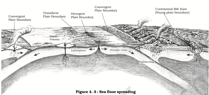
- Ocean Floor Configuration
- Continental margins (shelf, slope, rise)
- Shelves - 1°(gradient), 80 km(Average width, Chile - 0 , Siberian - 1500km), depth (30-600m), Sedimentary deposits, fossil fuels, Slope - 2-5°, depth(200 and 3,000 m)
- Abyssal Plains - depth(3,000 and 6,000m), clay, silt.
- Trenches - 3-5 km deeper
- Mid-oceanic ridge
- 2500 m tall
- Outside ocean - ICELAND
- Seamounts - 3000-4500m tall, inside ocean, EMPEROR SEAMOUNT, HAWAII
- Guyots - flat topped seamount
- Submarine canyon
- Atoll
- Continental margins (shelf, slope, rise)
- Temperature & Salinity of Oceans
- Temperature - variation in density
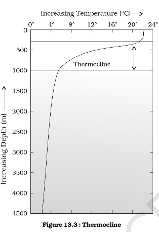
- Data
- Equator - 27°C
- 20° latitudes - 22°C
- 40° latitudes - 14° C
- Poles - 0° C
- 19° C and 16° C (average annual temperatures for the northern and southern hemisphere) - continentality
- Factors
- Latitude, Continentality & Maritime effect, Ocean Currents, Melting of glaciers, Winds blowing over the sea
- Salinity
- Factors
- evaporation and precipitation, freezing and thawing, river drains, winds, currents)
- Data
- brackish water - 24.7 ppt (highest)
- Open ocean - (33 - 37), landlocked - 41(red sea)
- halocline - here salinity increase sharply
- The lower salinity water rests above the higher salinity dense water.
- Factors
- Temperature - variation in density
- Movement of Oceans – Waves, Tides, Currents
- Waves - a long body of water moving in to and fro motion while without net movement of particle.
- Forces - wind(horizontal), gravity(vertical)
- Tides - alternate rising and falling of sea usually at a fixed interval.
- Centrifugal force, gravitational pull of moon and sun
- Semi-diurnal tide - 2H2L/D
- Diurnal tide - 1H1L/D
- Spring tides(S+M) - 2/M - new moon, full moon
- Neap tides (S<>M)
- Current
- Currents are long-distance, large, slow-moving unidirectional movement in the oceans, nearly round the year
- Warm -
- east coast of continents in the low and middle latitudes (true in both hemispheres). In the northern hemisphere they are found on the west coasts of continents in high latitudes.
- GULF STREAM, NORTH ATLANTIC drift
- Cold -
- West coast of the continents in the low and middle latitudes (true in both hemispheres) and on the east coast in the higher latitudes in the Northern Hemisphere.
- Example
- LABRADOR
- West wind drift - also known as ANTARCTIC CIRCUMPOLAR CURRENT (ACW direction)
- Forces - temperature, salinity, gravity, surface global winds, Coriolis force, topography of ocean floor
- Issues
- Melting of ice caps, warming of oceans faster
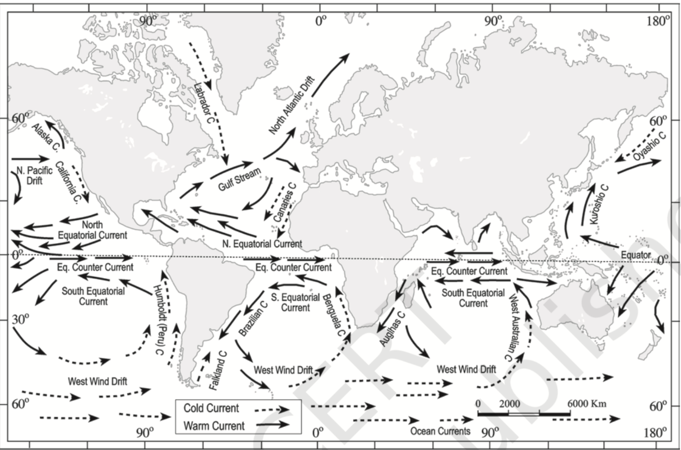
- Role in fishing industries
- Nutrient Upwelling
- Fish Migration
- Temperature Regulation
- Habitat Formation
- Transportation of Larvae
- Impacts on Marine Life
- Upwelling currents bring nutrient-rich waters from the deep ocean to the surface supporting rich fisheries.
- Influence migration patterns of marine species
- Help in the dispersal of larvae and eggs, ensuring the spread of species across different regions
- Impact on Coastal Environment:
- Regulate sea temperature affecting marine biodiversity
- Affect weather and climate patterns :
- Moderate temperatures by NORTH ATLANTIC drift
- Reducing precipitation by CANARIES
- Waves - a long body of water moving in to and fro motion while without net movement of particle.
- Thermohaline circulation
- ATLANTIC MERIDIONAL OVERTURNING CIRCULATION(AMOC)
- Due to the freezing of the surface water in the polar North Atlantic region
- ATLANTIC MERIDIONAL OVERTURNING CIRCULATION(AMOC)
- Water mass : large bodies of relatively uniform temperature, salinity and density
- Impacts on Marine Life
- Supports Thermohaline Circulation:
- ANTARCTIC BOTTOM WATER (AABW) influences AMOC
- Water mixing between two water masses create distinct habitats for marine species
- Formation of anoxic (oxygen-poor) zone in BLACK SEA
- Habitat Creation
- E.g. deep-sea brine pools and hydrothermal vents along mid-ocean ridges
- Supports Thermohaline Circulation:
- Impacts on Marine Life
Climatology
Factors/elements of Weather and Climate
- Temperature.
- Pressure.
- Winds.
- Humidity - Precipitation, Clouds, Condensation
- Sunlight.
Earth’s Atmosphere – Composition & Structure
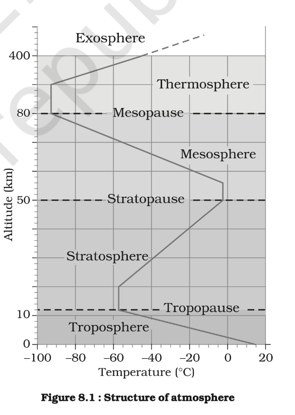
- Troposphere determines weather processes
- Global wind circulation
- Temperature gradient
- Geochemical cycles -
- Water cycle - vapor and cloud formation
- Carbon cycle - respiration, photosynthesis
- Weather system - cyclones, fronts, anticyclones, etc. develop here
- Jet streams affects temperature and precipitation patterns
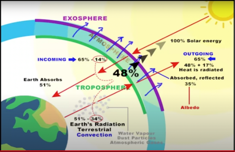
- Insolation and absorption of outgoing terrestrial radiation
- Heat Exchange : greenhouse effect
Solar Radiation, Heat Budget & Temperature
- Heat Budget
- Vertical heat budget
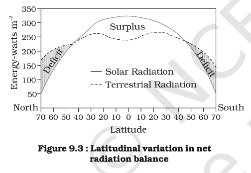
- Horizontal heat budget -
- Vertical heat budget
- Factors affecting insolation - Rotation, Revolution, Axial tilt, Aspect, clouds, sunspots
- Temperature
- latitude
- altitude
- distance from the sea
- air-mass circulation
- ocean currents
- local aspects - Slope, Vegetation, surface
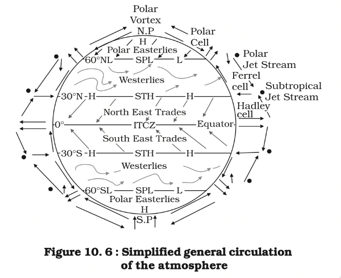
Atmospheric Circulation & Weather Systems
- Winds have forces -
- pressure gradient force
- frictional force
- Coriolis force
- gravitational force acts downward
- Temperature inversion
- Radiation - Cold winter nights, clear sky, still air.
- Subsidence - Valley breeze (day -> air moves up the valley), mountain breeze(night -> cool air -> down the valley)
- Marine - Land breeze (night), sea breeze(day)
- Frontal
- Air mass: homogeneous, little horizontal variation in temperature and moisture
- Maritime tropical (mT)
- Continental tropical (cT)
- Maritime polar (mP)
- Continental polar (cP)
- Continental arctic (cA)
- Fronts: (middle latitudes, steep gradient in temperature and pressure)
- (a) Cold; (b) Warm; (c) Stationary; (d) Occluded
- Air mass: homogeneous, little horizontal variation in temperature and moisture
Precipitation
- Sleet
- Hail
- Snow
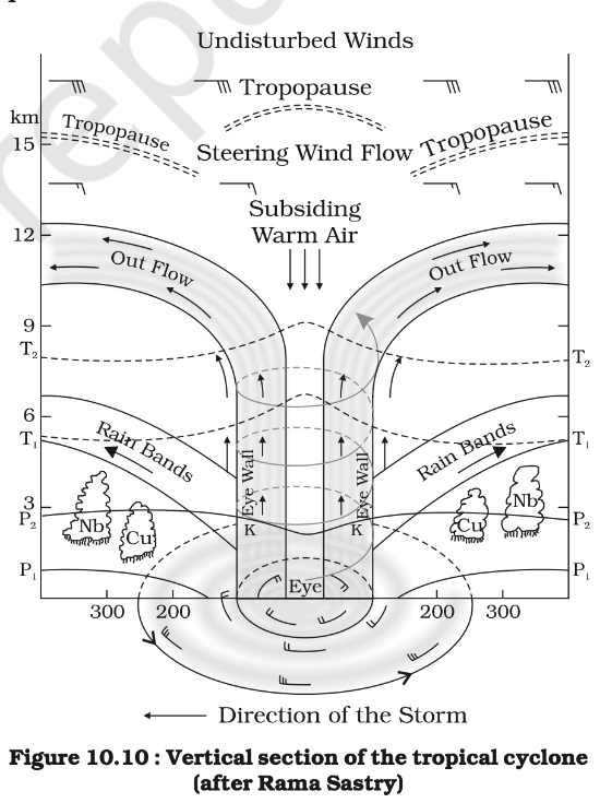
Cyclones
| Extra Tropical Cyclones | Tropical Cyclones |
|---|---|
| - Clear frontal system - Cumulus clouds - Large area, land and sea - Mid and high latitude - Anticlockwise cyclonic circulation - West to east | - Violent storms, heavy rainfall - Higher wind velocity - cumulonimbus clouds - East to west - Originate over Sea - Cyclones (Indian Ocean), Hurricanes (Atlantic), Typhoons (Pacific and South China Sea), and Willy-willies (Australia). |
Conditions
- Large sea surface ( >27° C)
- Coriolis force
- Small variations in the vertical wind speed
- A pre-existing weak- low-pressure area or low-level-cyclonic circulation
- Upper level atmospheric divergence
- Tornadoes generally occur in middle latitudes. The tornado over the sea is called water spouts.
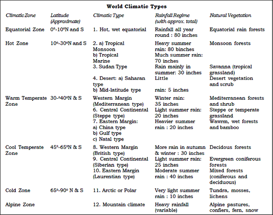
World Climate
Soil Geography
- Soil & Soil Contents
- Mineral particles, Humus, Water, Biotic
- Process of Soil Formation (or pedogenesis)
- Weathering, Erosion, Organic matter -> Microorganisms (bacteria, mosses, lichens), Time. -> Soil (Tada!)
- Soil Forming Factors
- Parent material - texture, structure, mineral and chemical composition
- Topography - slope, insolation, water
- Climate - moisture, temperature, precipitation
- Biological activity
- Time
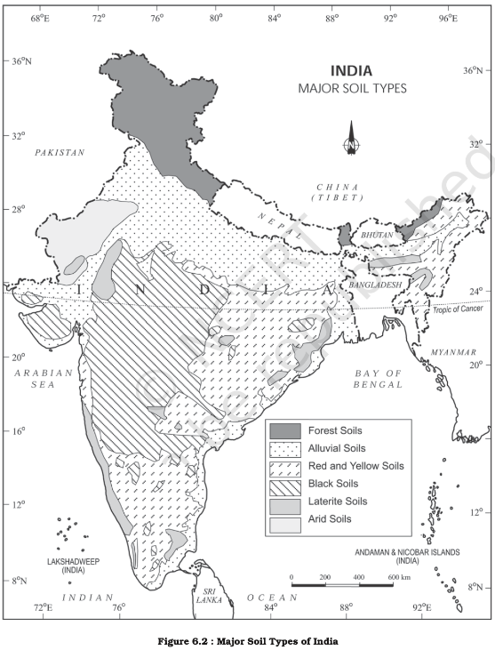
- Types of Soils (examples)
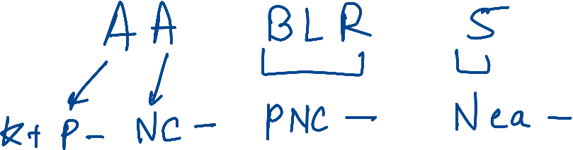
- Alluvial soils (K+, P-)
- 40 per cent of the total area, River Plains
- Rich in potash but poor in phosphorous
- Khadar (new alluvium) and Bhangar (older alluvium)
- sandy loam to clay
- light grey to ash grey
- Arid soils (CN-)
- red to brown in colour.
- Sandy and saline, lack moisture, humus, nitrogen.
- Black soils (PNC-)
- 16.6 percent of the total area of India
- Extremely fertile and can produce high agriculture yields due to elevated moisture holding capacity
- Deccan Plateau
- swell and become sticky when wet and shrink when dried (cracks -> self ploughing)
- rich in lime, iron, magnesia and alumina. Some potash. But lack phosphorous, nitrogen and organic matter.
- Laterite soils(PNC-, Ca-)
- high temperature and high rainfall -> intense leaching
- poor in organic matter, nitrogen, phosphate and calcium, while iron oxide and potash are in excess. ( cultivation )
- bricks
- Red and Yellow soils(PNC-)
- Low rainfall, high temperature -> weathering -> लाल हो जाती है
- Iron in crystalline and metamorphic rocks.
- poor in nitrogen, phosphorous and humus.
- Saline soils (Nca-)
- dry climate and poor drainage -> evaporation -> large sodium, potassium and magnesium salts
- lack in nitrogen and calcium
- intensive cultivation with excessive use of irrigation -> Alluvial soil -> Saline
- Peaty soils (C+)
- heavy rainfall and high humidity, vegetation
- rich humus and organic content
- heavy and black in colour
- Forest soils.
- Soil Erosion & Conservation
- Sheet erosion (Plains), Gully erosion (valleys)
- Conservation (Answer - 1. Slopes, 2. Plains)
- check open cultivable lands on slopes from farming. - shifting cultivation (X)
- Contour bunding, Contour terracing
- cover cropping, mixed farming and crop rotation
- Terracing, check dams
- Controlled grazing
- planting cover vegetation
- agro-forestry
- land use maps (Right use)
- Janbhagidari
- Central Soil Conservation Board
Important Geophysical Phenomena such as earthquakes, Tsunami, Volcanic activity, cyclone etc., geographical features and their location-
- Factors Causing Changes in Critical Geographical Features
- Impact of Changing Geographical Features
- Colour coded warning system
- Green - All is Well. No advisory. Carry on with daily activities
- Yellow - Be aware. Advice people to stay cautious and stay informed about weather updates
- Orange/Amber - Be prepared. Cyclone is expected to hit the area. Urge to take necessary precautions.
- Red - Take Action. Most severe warning. People must take immediate action to protect themselves and their property.
- Benefits of colour coded warning
- Clear communication
- Prompt action
- Reduced risk
- Comprehensible for large part of population
Changes in critical geographical features (including Water-bodies and Ice-caps) and in flora and fauna and the effects of such changes
- How can the mountain ecosystem be restored from the negative impact of development initiatives and tourism?
- Sustainable Development Practices:
- Environmental Impact Assessments
- Focus on Renewable Energy
- Eco-friendly Construction : Using sustainable materials and method
- Enforce stricter environmental regulation on developmental projects
- Establishing Protected Areas : NP, WLS, CR, CR ⭐ (Typo: “CR, CR” might be a repetition or intended to be different categories like Community Reserves and Conservation Reserves, but it’s repeated as is in the original text.)
- Habitat Restoration : e.g. wildlife corridors and breeding grounds
- Terracing and Contour Plowing
- Ecological Monitoring
- Tourism Management Strategies
- Tourism within Carrying Capacity
- Example: Limiting the number of visitors in Char Dham Yatra
- Ecotourism Promotion
- Community Involvement e.g. homestays and local experiences
- Waste Management : effective waste management systems; prevent littering and pollution.
- Restoration Projects : reforestation and planting native trees
- Tourist Awareness Campaigns
- Tourism within Carrying Capacity
- Sustainable Development Practices:
Physical Geography of India
- Physiography of India
- The Northern and North-eastern Mountains
- Hindukush and Sulaiman ranges in the north- west, Purvanchal hills in the north-east.
- Mountain passes such Khyber(PK), Bolan(Balochistan), Shipkila(HP), Nathula(SK), Bomdila(AP)
- The Northern Plain - Bhabar, Tarai, Alluvial plains (Khadar, Bhangar)
- The Peninsular Plateau
- Features - Tors, block mountains, rift valleys, spurs, bare rocky structures, The western and north western part of the plateau has an emphatic presence of black soil.
- The Deccan Plateau
- The Central Highlands
- The North-eastern Plateau
- The Northern and North-eastern Mountains
- The Indian Desert
- Features - mushroom rocks, shifting dunes and oasis
- The Coastal Plains
- Eastern - emerging coastal plain
- Western - submerging coastal plain
- The Islands.
- Gulf(large water body partially enclosed by land) of Mannar
- Palk Strait(narrow water body connecting two large water bodies)
- Why is India considered as a subcontinent
- Geographically separated from rest of Asia
- Himalayas, Thar Desert, Indian Ocean
- Geologically different : Indian Plate collided with Eurasian Plate about 65 mya.
- Diverse Climate : from tropical climate to alpine in Himalayas
- Culturally distinct : civilizational continuity since ancient times
- Unique languages, religions, and social structures
- Population Diversity : numerous ethnic groups and races
- Geographically separated from rest of Asia
- Drainage System
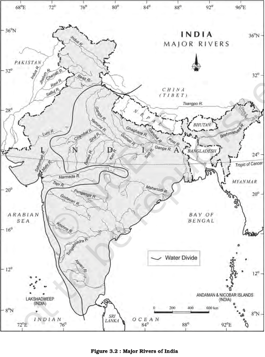
- Indus system
- Ganga System (VNKRD)
- Brahmaputra(Tsangpo) - Chemayungdung glacier, Mansarovar lake
- The Peninsular Drainage System
- Narmada, Mahanadi, Godavari, Krishna, Kaveri, Penner,
- Interlinking of Rivers
- Climate
- Soils in India
- Natural Vegetation
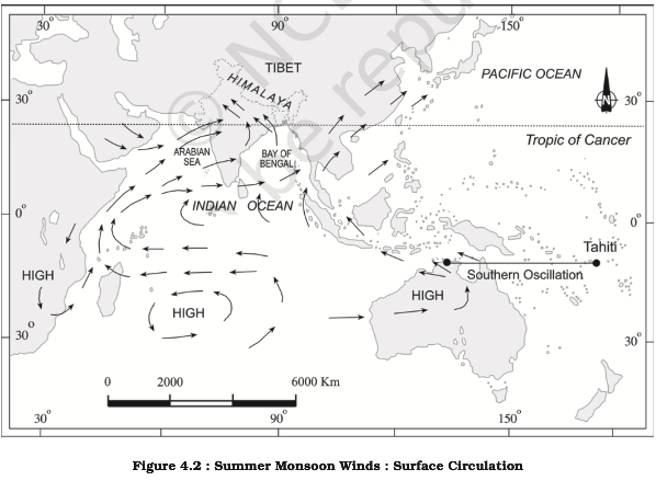
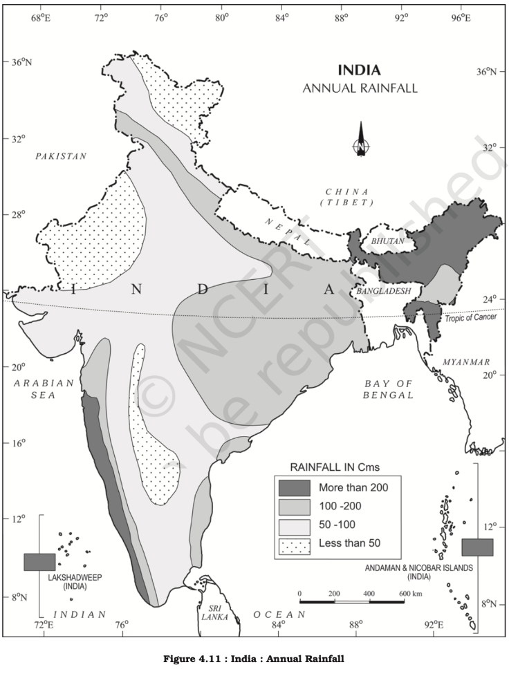
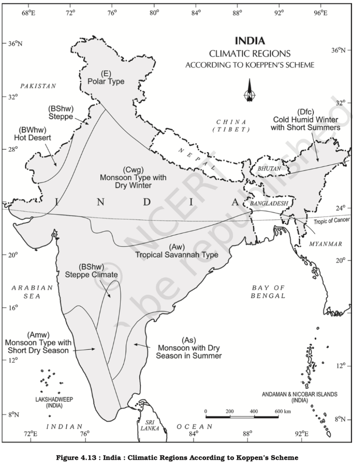
Distribution of Key Natural Resources across the world (including South Asia and the Indian sub-continent)
- Types of Resources
- On the Basis of Origin
- Ownership
- Individual ownership
- State ownership
- Common
- Exhaustibility
- FLAW-ME
- Multidimensional implications of uneven distribution of mineral oil in the world
- Economic
- Wealth inequality
- Uneven development
- Economic instability due to volatility in oil prices
- Import dependencies
- Political
- geopolitical power and influence of oil producing countries
- E.g. OPEC (Organization of the Petroleum Exporting Countries) and GCC
- Competition and conflict for control over oil resources
- Gulf War
- Foreign policy aimed at securing stable oil supplies for importing countries
- geopolitical power and influence of oil producing countries
- Social
- Labour migration
- E.g. millions of Indian migrants in Gulf
- Labour migration
- Environmental
- Pollution and degradation : oil extraction, transportation, combustion
- oil spill
- Climate change
- burning of fossil fuels
- Pollution and degradation : oil extraction, transportation, combustion
- Governance
- Resource curse : lead to corruption, economic mismanagement, and social instability.
- E.g. Venezuela
- Resource curse : lead to corruption, economic mismanagement, and social instability.
- Greater investment in alternative and renewable energy by countries lacking oil
- Technology development in oil exploration, extraction and processing
- E.g. offshore drilling and deep-sea technology
- Economic
Forest Resources
- Introduction
- Forest is any large area covered chiefly with trees and undergrowth (TN GODAVARMAN Case)
- According to INDIAN STATE OF FOREST REPORT (ISFR), the forest area covers 21.39 per cent of the total land area of the country.
- dense and open forests are 12.41 and 9.26 per cent respectively.
- Status of Forest Resources in India
- As per ISFR 2021, forest cover of India - 21.71%/7,13,789 sq km or 71.38 m ha
- Very dense forest (>70% tree canopy density) - 3.04%
- Moderately dense forest (40-70%) - 9.33%
- Open forest (10-40%) - 9.34%
- Scrub(<10) - 1.42%
- Recorded forest area of India - 7,75,288 sq km/23.58% or 77.53 m ha
- Tree cover - 2.91%/9.57 m ha
- Forest Cover and Tree Cover - 24.62%
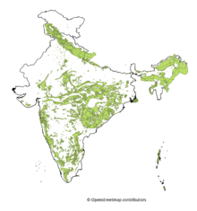
- Madhya Pradesh > AP > Chhattisgarh - highest forest cover
- Mizoram > Lakshadweep - highest percentage of forest cover
- As per ISFR 2021, forest cover of India - 21.71%/7,13,789 sq km or 71.38 m ha
- Types & Distribution – Grasslands, Forests etc.
- Tropical Evergreen and Semi Evergreen forests - rosewood, mahogony, aini, ebony, etc.
- Tropical Deciduous forests - Teak, sal, shisham, hurra, mahua, amla, semul, kusum, and sandalwood
- Tropical Thorn forests - babool, ber, and wild date palm, khair, neem, khejri, palas, etc.
- Montane forests - oak, chestnut, Pine, Deodar, walnut , higher altitudes - mosses and lichens.
- Littoral and Swamp forests -
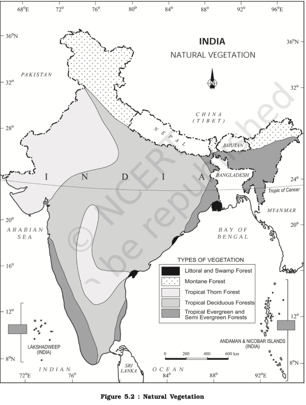
- Factors responsible for diversity of natural vegetation
- Climatic : diverse climate zones
- Example: The Western Ghats receive high rainfall supporting dense forests.
- Soil types
- Example: Black soil regions support cotton cultivation
- Topography
- Example: The Himalayan region supports alpine vegetation.
- Rainfall distribution
- Example: The Thar Desert has xerophytic vegetation due to low rainfall
- Temperature Variations:
- Altitude
- Human activity
- Example: Expansion of tea plantations in Assam has altered local vegetation.
- Climatic : diverse climate zones
- Causes of Depletion
- Impact on climate
- Reduced Carbon Sequestration
- Disruption of Water Cycle
- Forest Fires
- Soil erosion, and loss of biodiversity.
- Fragmentation of habitat - ecosystem degradation
- Loss of ecosystem services
- Conservation of Forests
- The forest policy aims to bring 33 per cent of the geographical areas under forest cover.
- Social forestry
- Agro-forestry and community-forestry
- Urban forestry
- Afforestation on degraded land
- Encourage substitution of wood
- Public participation including women for planting tress and preventing deforestation.
- Forest cover
- Significance of protected areas
- Habitat Protection for endangered, threatened, or endemic species
- Ecosystem services
- Biodiversity Conservation
- Ecotourism
- Scientific Research : study plant-animal interactions
- Cultural significance
- Climate change mitigation
- Water conservation
- Minor forest produce under FOREST RIGHTS ACT, 2006
- Includes all non-timber forest produce of plant origin including bamboo, brush wood, stumps, cane, tussar, cocoons, honey, wax, lac, tendu or kendu leaves, medicinal plants and herbs, roots, tubers and the like.
Land Resources
- Types
- Agricultural Land
- Forest Land
- Urban Land
- Wetlands
- Desert Land
- Industrial land
- Importance of Land Resources
- Food Security
- Economic Development
- Environmental Regulation
- Cultural and Recreational Value
- Land Utilisation
- Forests
- Barren and Wastelands
- Land put to Non-agricultural Uses
- Area under Permanent Pastures and Grazing Lands - owned by village panchayats
- Area under Miscellaneous Tree Crops and Groves (Not included in Net sown Area) - orchids and fruit trees
- Culturable Wasteland - left fallow (uncultivated) for more than five years
- Current Fallow - left fallow (uncultivated) < 1 agriculture year
- Fallow other than Current Fallow - 1 < left fallow < 5
- Net Area Sown
- Factors influencing Land Use Pattern
- Climatic Conditions
- Population Density and Urbanization
- Economic Activities
- Government Policies and Programs
- Challenges in land use
- Land Degradation : Soil erosion, salinity, waterlogging, and deforestation
- Urban Sprawl
- Inefficient Land Use : Fragmented land holdings, poor land management practices, and inadequate infrastructure
- Conflict Over Land Use : competing demands and claims
- Sustainable land use practices
- Integrated Land Use Planning: balancing agricultural, industrial, urban, and conservation needs.
- Soil and Water Conservation:
- Agroforestry
- Urban Land Management : green spaces, efficient public transport, and high-density housing
Agricultural Resources
- Types of Farming
- Subsistence Agriculture
- Plantation Agriculture
- Introduced by the Europeans in colonies
- Extensive Commercial Grain Cultivation - Entire operations of cultivation from ploughing to harvesting are mechanised.
- Mixed Farming - Crop rotation, Intercropping, livestock rearing, capital intensive
- Dairy Farming
- Mediterranean Agriculture - Viticulture
- Horticulture
- Collective Farming , Cooperative farming
- Dryland farming
- Rainfall < 75 cm - Millets (ragi, bajra, moong, gram and guar) and fodder crops
- Wetland farming
- rice, jute and sugarcane, aquaculture
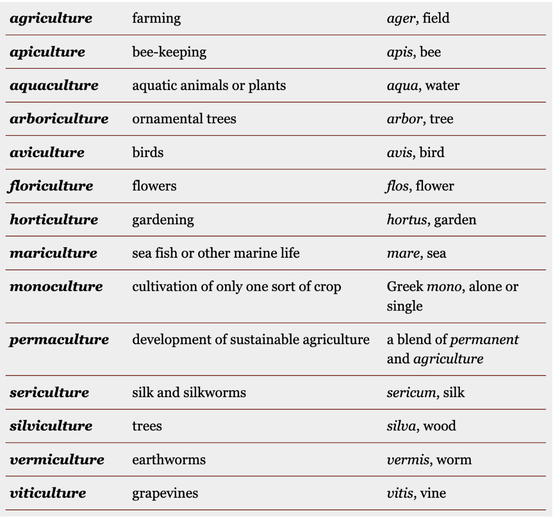
- rice, jute and sugarcane, aquaculture
- Cropping Patterns
- However, In southern parts, temperature remains high throughout the year. Hence tropical crops can be grown in winters as well.
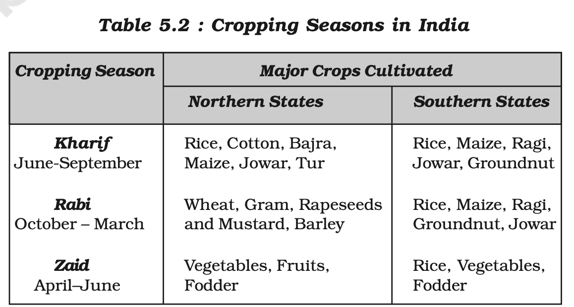
- However, In southern parts, temperature remains high throughout the year. Hence tropical crops can be grown in winters as well.
- Contribution to Economy, Employment & Output
- Food Security
Water Resources
- Data
- About 71 percent of the Earth’s surface is water-covered
- Only 2.5% of Earth’s water is freshwater
- 68 percent found in icecaps
- 30 percent found as groundwater
- 0.3 percent found in surface lakes and rivers.
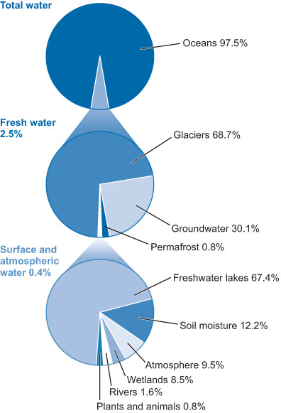
- Water Resources Assessment Report by Ministry of Jal Shakti
- 54% population faces high water stress - NITI Aayog
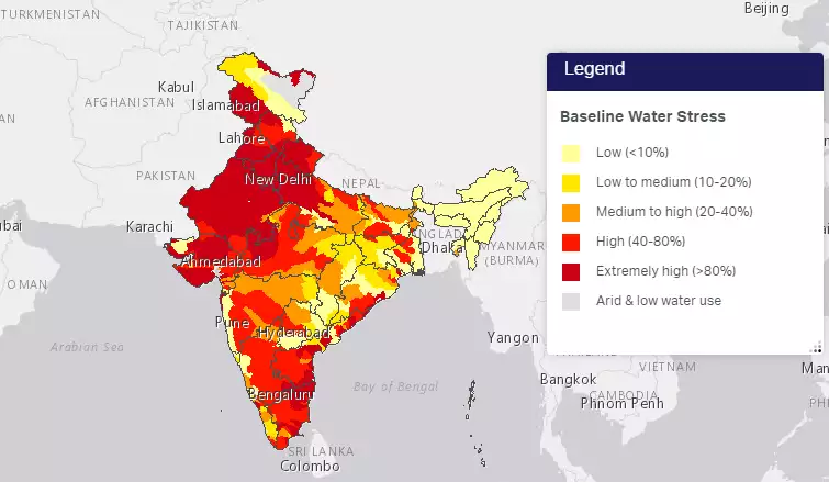
- 54% population faces high water stress - NITI Aayog
- Reasons for water stress
- Large and growing population
- Urbanization : demand outstripping supply
- Uneven distribution
- Agricultural Practices: Inefficient irrigation practices and water-intensive crop
- Water pollution : industrial discharge, untreated sewage
- Yamuna one of most heavily polluted
- Unsustainable Practices : Overexploitation of groundwater resources, overuse of water
- Poor water management practices : lack of proper infrastructure, inefficient water use, limited rainwater harvesting
- Climate change leading to severe floods, draughts, snowmelt and glacier retreat
- Transboundary water conflicts
- Factors affecting water availability
- Rainfall Pattern
- Groundwater Availability
- Water Management Practices: irrigation methods, rainwater harvesting, wastewater treatment
- Climate conditions
- Marine & Freshwater
- Water Scarcity & Need For Conservation
- Integrated Water Resources Management
- Fisheries
- Central Ground Water Board (CGWB)
- Global warming may triple groundwater depletion rates over the coming decades.
- Interlinking of Rivers
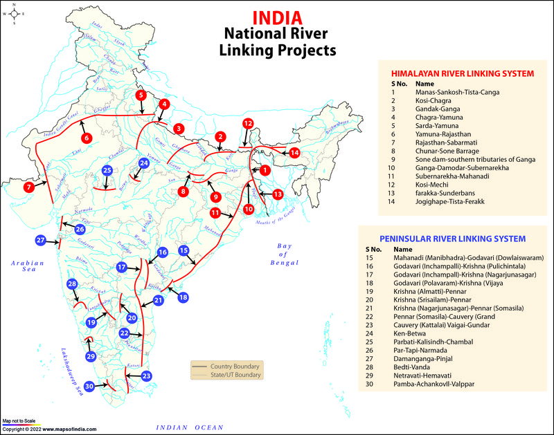
- Benefits
- Flood Control
- Gandak-Ganga link can reduce flood risk in Northern plains
- Drought Mitigation
- The Ken-Betwa Link can potentially alleviating water scarcity in the Bundelkhand region.
- Enhanced Navigation
- Godavari-Krishna-Pennar-Cauvery can enhance trade and connectivity
- Hydropower Generation
- E.g. Dhaudhan Dam on Ken Betwa Link
- Agricultural Productivity:
- PKC-ERCP Link Project can benefit water stressed regions of Rajasthan and Madhya Pradesh ⭐ (PKC-ERCP is not a standard acronym for a specific interlinking project. It might be a combination of projects or a typo.)
- Flood Control
- Challenges
- High Costs : in construction of canals, tunnels, and barrages
- Environmental Impact : disrupt ecosystems downstream, impacting aquatic life, deforestation
- Panna Tiger Reserve submergence due to Ken-Betwa Link
- Technical and Logistical Challenges because of varying hydrology, geology and climate conditions
- Displacement and resettlement of local communities by construction projects - loss of livelihoods and culture
- Narmada Bachao Aandolan against projects like the Sardar Sarovar dam
- Concern about water quality : mixing of water can spread pollutants and disease
- Sustainability : keeping in mind future variations in rainfall patterns due to climate change
- Inter-State Water Disputes
- Benefits
- Way forward
- Targeted interlinking projects
- Alternatives like:
- water conservation practices
- rainwater harvesting
- sustainable agricultural practices
- efficient irrigation methods
- Water harvesting techniques
- Rooftop Rainwater Harvesting
- Constructing barrels, tanks, underground cisterns.
- Surface Runoff Harvesting
- Swales, contour trenches, percolation pits, lakes, ponds
- Check Dams
- Traditional Techniques:
- Tanks and ponds, Baoris, Tankas,
- Modern Technique
- Recharge Wells
- Rain Gardens
- Agricultural Water Harvesting
- Farm Ponds
- Mulching
- Watershed Management
- Contour bunding, Gully plugging
- River runoff
- Construction of Dams and Canals
- Rooftop Rainwater Harvesting
- Water resource management in urban areas
- Impact of melting of Himalayan glaciers on the water resources of India
- Short-term surge but long term decline in river flow
- Disruption of seasonal flow patterns could severely affect agricultural productivity
- Flash floods and GLOF
- Could disrupt monsoon due to changing wind patterns and temperature
- Agricultural stress
- Water scarcity issue
- Transboundary water conflicts
- Impact of global warming on coral life system
- Coral bleaching : zooxanthellae detach from coral due to rising temperature
- Mass bleaching in the Great Barrier Reef in Australia in 2016, 2017
- Ocean acidification : reduces the availability of carbonate ions weakening coral
- Increasing cyclone number and intensity can break coral structures
- Sea Level Rise : can affect photosynthesis due to reduced sunlight
- Change in ocean currents can reduce the nutrients essential for coral growth
- Increased susceptibility to disease leading to high mortality rates.
- Coral bleaching : zooxanthellae detach from coral due to rising temperature
- Consequences of water crisis
- Food Insecurity : limits agricultural productivity
- Environmental Degradation and loss of biodiversity
- Social Conflicts for scarce water resources
- Economic Impact : more disruptions and increased cost for families, industries and agricultural activities
- Health Issues : Cholera, dysentery and other waterborne disease
- Measures
- Urban areas
- Mandatory Rainwater Harvesting
- Rooftop Harvesting
- Chennai has mandated rainwater harvesting
- Check Dams and Ponds:
- E.g. Pani Panchayat movement in Maharashtra
- Urban Planning : integrating large scale water harvesting into zonal plans
- Greywater recycling
- Industrial reuse in cooling and cleaning
- Zero Liquid Discharge (ZLD) system
- Domestic reuse for irrigation and toilet flushing
- Urban stormwater management plans to capture runoff
- Developing permeable pavements, green roofs, lakes and waterbodies
- Developing green cover
- Reviving wetlands in cities
- Appropriate permeable construction material and percolation pits
- Mandatory Rainwater Harvesting
- Overall
- Watershed development
- Water-Saving Technologies
- Drip and sprinkler irrigation
- Smart Irrigation Systems based on IoT sensors
- Behavioral Changes through public awareness and incentives
- “Day Zero” campaigns
- LiFE Campaign
- Sustainable Agriculture
- Drought-Resistant Crops e.g. Millets
- Agroforestry and Mixed Cropping; cover cropping; mulching
- Integrated Water Resource Management (IWRM)
- Strict regulation and enforcement for water extraction and pollution
- Community-Based Management
- Hivre Bazar village model
- Urban areas
- National Watershed Project
- Increase water availability : rainwater harvesting through check dams, percolation tanks, and farm ponds, groundwater recharge
- Enhanced soil moisture retention and reduce runoff : contour bunding, terracing, and vegetative cover
- Improve crop yields
- Crop diversification : including horticulture and cash crops.
- Reducing soil erosion :
- Increase livelihood opportunities in farming and allied sectors
- Examples
- Sukhomajri Model (Haryana)
- Ralegan Siddhi (Maharashtra)
- Hiware Bazar (Maharashtra)
Mineral Resources
- Classification and Occurrence of Minerals
- Organic Minerals
- Coal
- 80% bituminous type and is of non-coking grade.
- 97 % - Damodar, Sone, Mahanadi and Godavari valleys
- Jharkhand has highest reserves
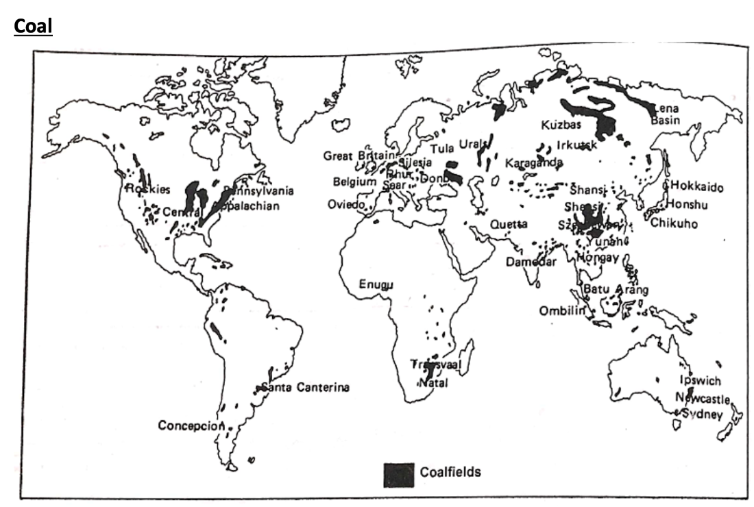
- Coal
- Organic Minerals
- Petroleum
- Assam, Gujarat and Mumbai High, Krishna-Godavari and Kaveri basins.
- Naharkatiya - Assam
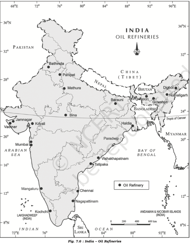
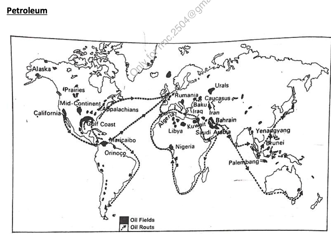
- Natural gases
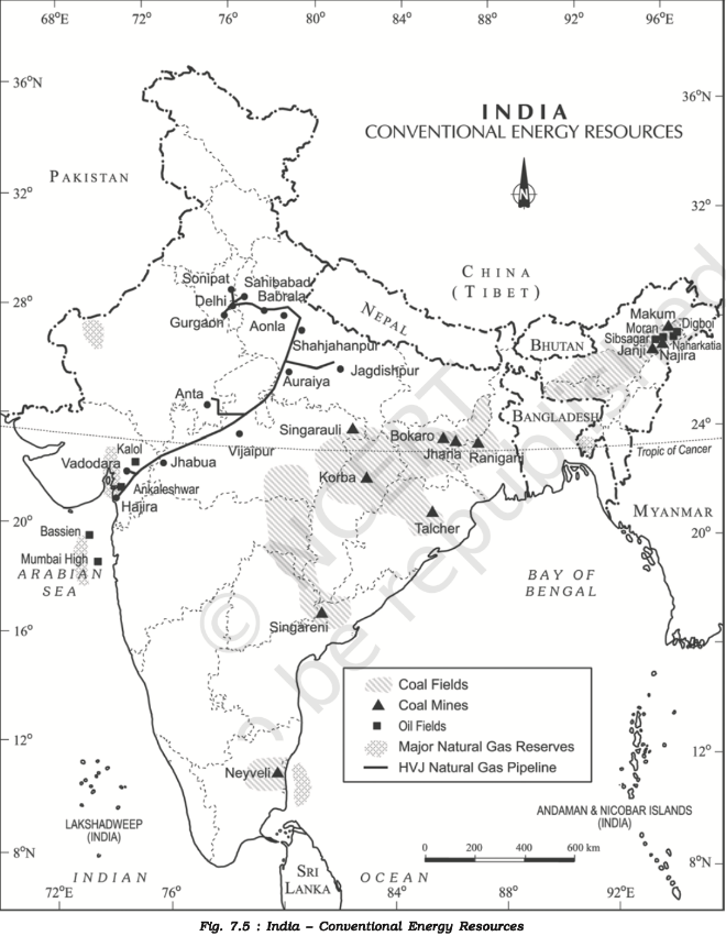
- Inorganic minerals
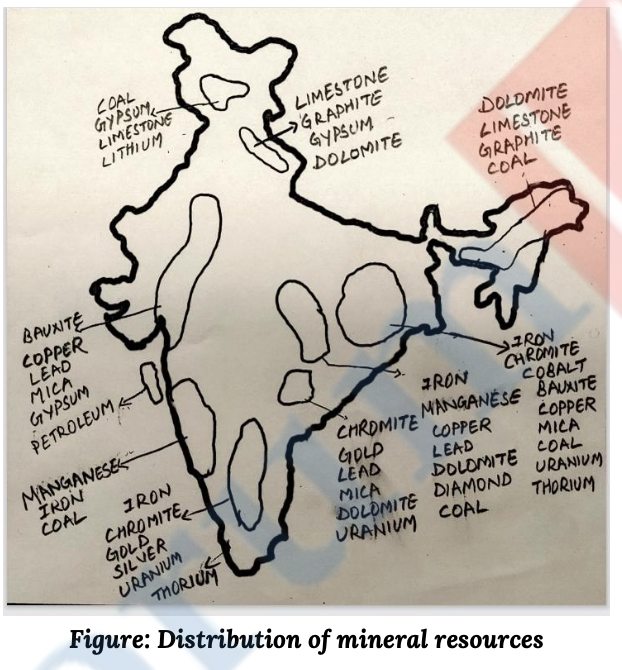
- Metallic - precious, ferrous and non ferrous
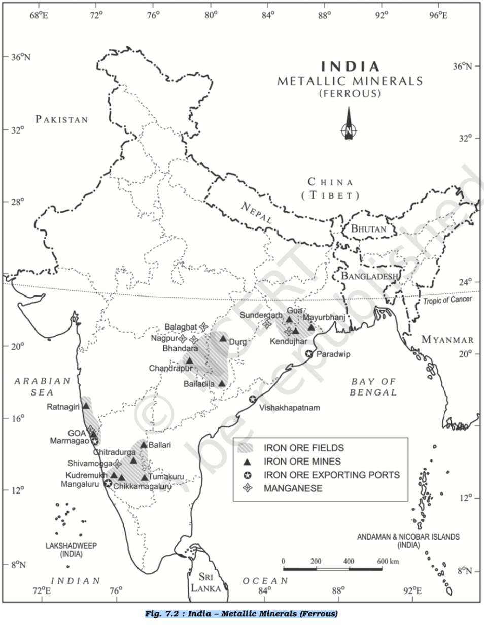
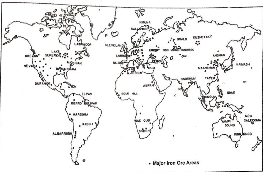
- Ferrous
- Iron ore(haematite and magnetite), coal, manganese - Chhotanagpur (Jharkhand), Odisha Plateau, Chhattisgarh.
- Mayurbhanj, Chandrapur, Kudremukh ⭐ (Chandrapur is not a primary iron ore region like Mayurbhanj or Kudremukh; it’s known for coal. This might be a misattribution or a less significant deposit.)
- Ferrous
- Non - Ferrous
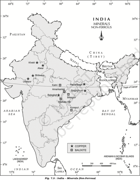
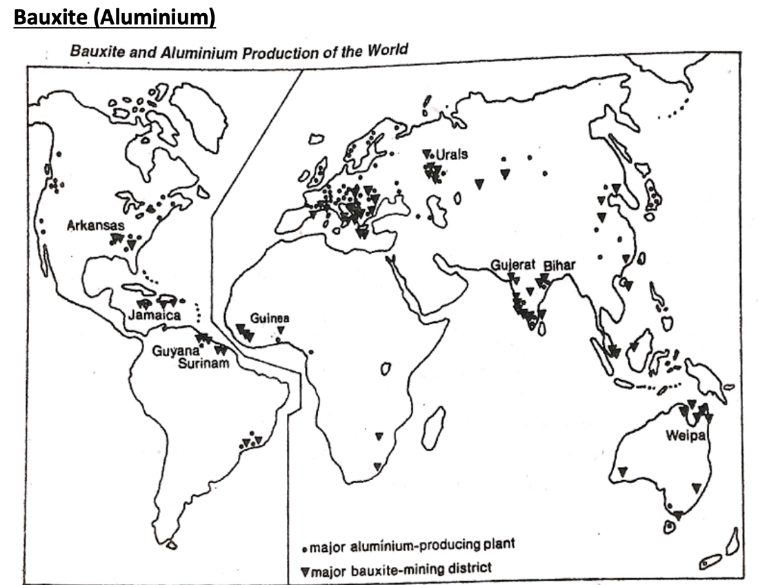
- Bauxite - Odisha, Amarkantak plateau, Ratnagiri, Katni
- Copper, zinc - Dharwar region Rajasthan, Singhbhum, Jharkhand, Balaghat M.P. and Jhunjhunu and Alwar, Khetri Rajasthan. ⭐ (While Khetri is famous for copper, zinc is primarily found in Zawar, Rajasthan, not typically associated with Khetri in major deposits.)
- Gold - Alaska, California, Lake Baikal, Kalgoorlie (Australia)
- Metallic - precious, ferrous and non ferrous
- Non metallic
- Limestone, sulphate, phosphate, nitrate (example cement)
- Monazite and thorium
- Malabar coast, Kerala
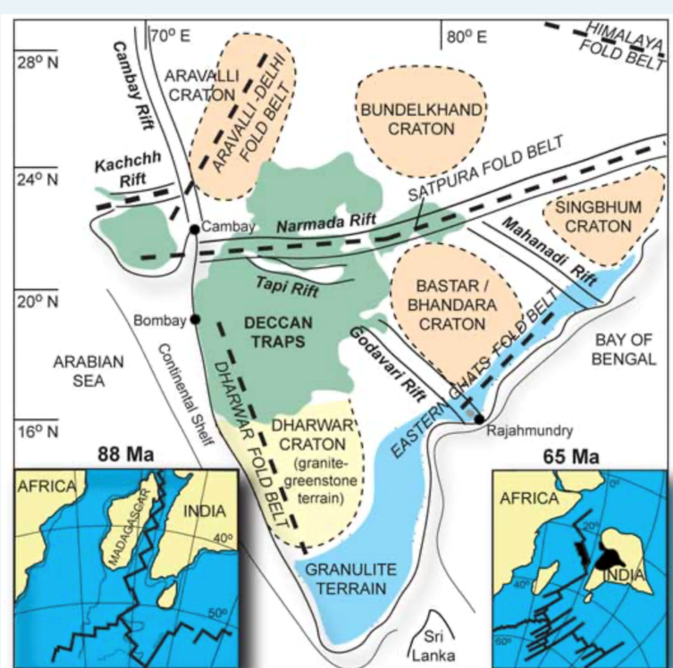
- Sandstone, granite, marble - Aravalli
- Lithium
- Reasi District of J&K
- Uranium
- Turamdih - JK ⭐ (Turamdih is in Jharkhand, not Jammu & Kashmir.)
- Athabasca Basin - Canada (20% world’s reserves of uranium)
- Major Minerals
- Conservation of Minerals
- Classification of Energy Resources – Conventional & Non-Conventional
Energy Resources
- Occurrence of Energy Resources
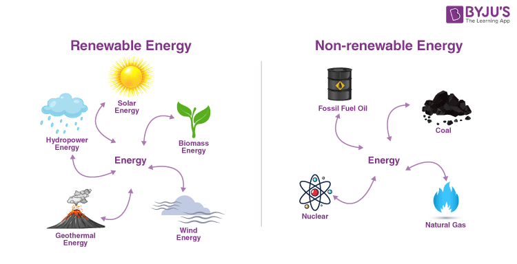
- Renewable energy refers to energy derived from natural sources that are replenished continuously and sustainably.
- IREDA - INDIAN RENEWABLE ENERGY DEVELOPMENT AGENCY
- IRENA - INTERNATIONAL RENEWABLE ENERGY AGENCY
- IEA - INTERNATIONAL ENERGY AGENCY
- Conservation of Energy Resources
- Potential of renewable energy
- Solar Energy :
- High insolation - 4-7 kWh/m²/day, with around 300 sunny days annually.
- Estimated Potential: Approximately 748 GW assuming 3% of the wasteland area is used for solar power projects. (IREDA)
- Example - Bhadla Solar Park, Rajasthan - capacity 2.245 GW
- Wind Energy
- Estimated Potential: Over 302 GW at 100 meters hub height
- Biomass Energy
- Estimated Potential: About 25 GW (MNRE).
- Hydropower
- Estimated Potential: Around 145 GW (CENTRAL ELECTRICITY AUTHORITY)
- Geothermal Energy
- Estimated Potential: About 10 GW (MNRE)
- Tidal and Wave Energy
- Estimated Potential: About 12 GW (MNRE)
- Key Areas: Gulf of Kutch, Khambhat, Sundarbans
- Solar Energy :
Resource potentials of the long coastline of India
- Fisheries and Aquaculture
- Mineral Resources: ilmenite, monazite, rutile, and zircon
- Oil and Natural Gas : Mumbai High Field and the Krishna-Godavari Basin
- Renewable Energy: wind and tidal energy
- Shipping and Ports : BHARATMALA Project
- Tourism : beaches, backwaters, historical sites, and cultural landmark attract tourists
- Goa, Kerela, A&N Islands
- Salt production
Factors responsible for the location of primary, secondary, and tertiary sector industries in various parts of the world (including India)
- Primary |Red-collar workers
- Hunting and gathering, pastoral activities, Fishing, Forestry.
- Agriculture
- Mining and quarrying.
- open-cast
- shaft method
- Water Related(Ocean, lakes) - fishing
- Secondary - Value addition to natural resources | Blue-collar
- Manufacturing - mass production of identical products
- Processing
- Construction (infrastructure) industries
- Tertiary | White-collar
- Trade
- Transport
- Communication
- Services
- Quaternary
- Information based
- R&D
- Quinary | Gold collar
- Specialist
- Decision makers
- Consultants
- Policy formulators
- Senary (proposed) - Management of intellectual property and the development of new technologies.
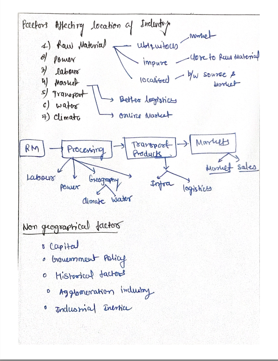
- Location & Distribution of the Industries on the Basis of
- Real people love making terrific good coffee but govt love CHAI
- Raw Material (weight losing, perishable -> industry in close proximity)
- Power
- Skilled workforce
- Climate
- Water
- Market (heavy machines, cotton textile, petroleum)
- Infrastructure - Transport, Storage
- Brownfield industries
- Capital
- Communication
- (Government) Industrial policy, Grants & Financial Incentives
- Land
- Export potential
- Classification based on nature of manufactured products
- Metallurgical Industries
- Mechanical Engineering Industries
- Chemical and Allied Industries
- Textile Industries
- Government initiatives - PM MEGA INTEGRATED TEXTILE REGION & APPAREL (MITRA) Parks
- Food Processing Industries
- Electricity Generation
- Electronics
- Communication Industries
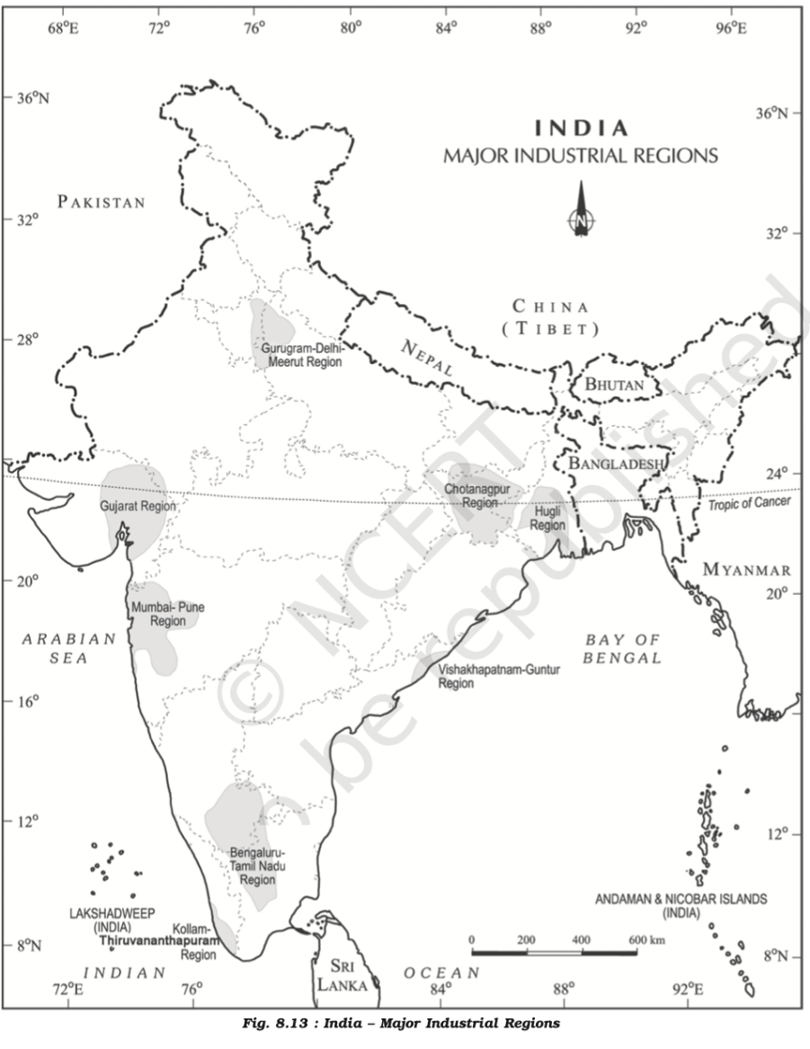
- Distribution of Major Industries –
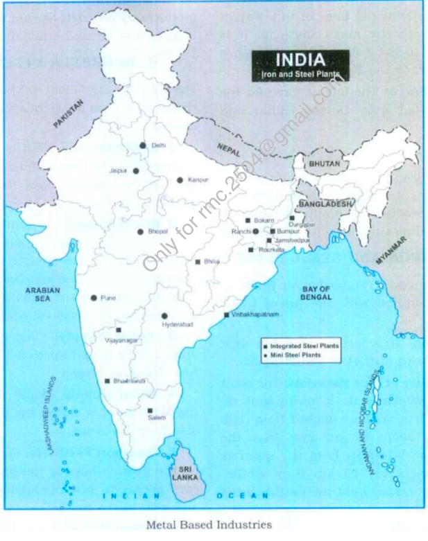
- Iron & Steel
- Near Raw Material
- TISCO
- SAIL - Rourkela, Bhilai, Durgapur, Bokaro
- Away
- Improved Transportation and infrastructure
- The Durgapur Steel Plant
- Proximity to market
- Port Facilities and Export Opportunities
- Vizag Steel Plant, in Vishakhapatnam - port based
- Government incentives
- Proximity to reliable and affordable energy sources
- Vijaynagar Steel Plan
- Near Raw Material
- Iron & Steel
- Cotton Textile
- Non weight losing -> close to market
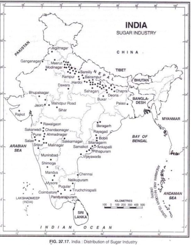
- Sugar
- Weight losing
- MH, UP(Ganga-Yamuna Doab & Tarai Region)
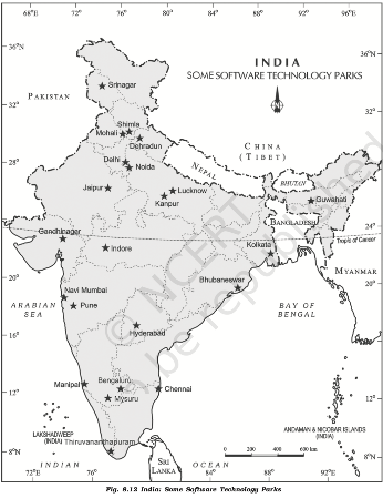
- IT
- Petrochemical
- Polymers(ethylene and propylene)
- Synthetic fibres,
- Elastomers
- Surfactant intermediate
- Agglomeration & Footloose Industries
- Rubber
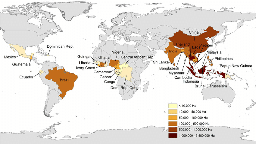
- Southeast Asia - 91% - Thailand, Malaysia, Vietnam, Indonesia
- Africa - 6% - Nigeria, Ghana, DRC
- Environmental impacts
- Deforestation : leading to loss of biodiversity
- Habitat Loss: threatened species like orangutans are displaced from homelands
- Soil Degradation : loss of soil fertility, erosion and compaction
- Water stress : rubber plantation require significant water
- Chemical pollution : excessive use of fertilizers, pesticides, and herbicides
- Loss of ecosystem services like water regulation, carbon sequestration
- Human wildlife conflict - loss of habitat leading to animals entering agricultural fields and raiding crops
- Pollution – sulphate are released from latex processing facilities
- Looking Ahead
- Replantation to minimize deforestation
- Reduced pesticide and fertilizer use
- Balancing economic growth with conservation
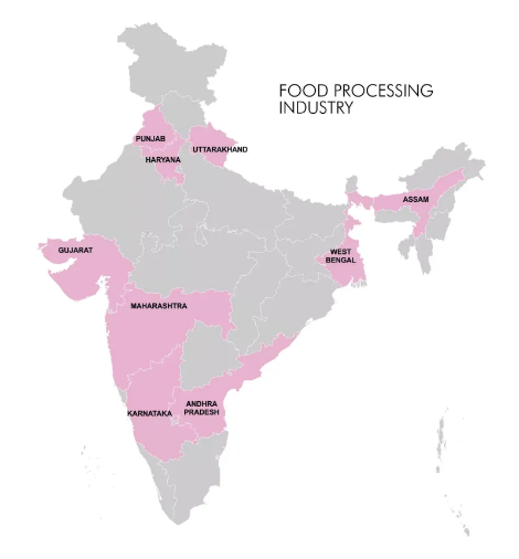
- Food Processing
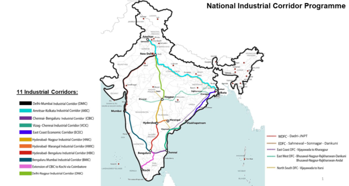
- Industrial Corridors
- are strategically planned areas along transportation lines that aim to boost industrial development.
- Significance
- Boost Industrial Development: by creating dedicated zones
- Job creation
- Improve Connectivity and infrastructure
- Attract Investments
- Balanced Regional Growth
- Improve Efficiency and Productivity
- Development of new cities
- Example: Dholera in Gujarat, part of the DMIC
- Main characteristics
- Focus Sector : sectors like automobiles, textiles, pharmaceuticals, or food processing depending on region
- Multimodal Connectivity
- Special Economic Zones (SEZs) : offer special incentives like tax breaks and simpler regulation
- Social Infrastructure
- Sustainable Practices: renewable energy, waste management, water conservation
- Industrial Corridors with their Main Characteristics
- Delhi-Mumbai Industrial Corridor (DMIC)
- Length : 1,500 km.
- States Covered
- Focus Areas
- Chennai-Bangalore Industrial Corridor (CBIC)
- Amritsar-Kolkata Industrial Corridor (AKIC)
- Bengaluru-Mumbai Industrial Corridor (BMIC)
- Vizag-Chennai Industrial Corridor (VCIC)
- East Coast Economic Corridor (ECEC)
- Delhi-Mumbai Industrial Corridor (DMIC)
- are strategically planned areas along transportation lines that aim to boost industrial development.
Human Geography of India
- Social/cultural
- Demography
- Urbanization
- UNITED NATIONS DEVELOPMENT PROGRAMME (UNDP) has outlined these priorities as part of its ‘Urban Strategy’.
- Housing
- ‘Education’, ‘Primary Health care’, ‘Clean Water and Sanitation’.
- Improving women’s access to ‘Basic Services’ and government facilities.
- Upgrading ‘Energy’ use and alternative ‘Transport’ systems.
- Reducing ‘Air Pollution’.
- UNITED NATIONS DEVELOPMENT PROGRAMME (UNDP) has outlined these priorities as part of its ‘Urban Strategy’.
- Census
- Political
Economic Geography of India
- Agriculture
- Reasons for agricultural turnaround
- Green Revolution
- Introduction of High-Yielding Varieties (HYVs)
- Use of Chemical Fertilizers and Pesticides
- Improved Irrigation Infrastructure
- Agricultural Policies and Reforms
- Minimum Support Price (MSP)
- Agricultural Credit and Subsidies
- Land Reforms
- Technological Advancements
- Mechanization
- Research and Development
- Expansion of Cropped Area and Diversification
- Increased Cropped Area
- Crop Diversification
- Market Reforms and trade liberalization
- Development of agricultural Infrastructure: storage facilities, cold chains, and rural roads.
- Government Schemes
- NATIONAL FOOD SECURITY MISSION (NFSM):
- PRADHAN MANTRI KRISHI SINCHAI YOJANA (PMKSY)
- Export Promotion Measures
- Agri-Export Zones (AEZs)
- Promotion of Food Processing Industries
- Green Revolution
- Reasons for agricultural turnaround
- Fisheries
- Components of blue economy
- Sustainable fisheries
- Renewable energy
- Smart shipping and transport
- Conservation of marine life
- Protection of coastal communities
- Marine biotechnology
- Tackling marine litter and ocean pollution
- Significance
- Food Security : provide essential protein and nutrition to millions of people.
- Economic Growth
- Employment : employ over 14 million people, including fishers, fish farmers, processors, and traders.
- Export Opportunities
- Problems
- Resource constraints : Limited availability of quality fish seeds and feed hamper
- Inadequate infrastructure for storage, processing, and transportation leads to post-harvest losses.
- Poor water quality and insufficient water management practices hampers fish growth and health
- Eutrophication
- Limited access to credit and financial services
- Lack of access to modern technology and scientific knowledge
- E.g. techniques like biofloc technology.
- Environmental Concerns: Overfishing, habitat destruction
- Inefficient supply chains and market access limit profitability of farmers
- Way forward
- Develop hatcheries and feed mills to ensure a steady supply of fish seeds
- The NATIONAL FISHERIES DEVELOPMENT BOARD (NFDB)
- Building and upgrading infrastructure for storage, processing, and transportation
- The PRADHAN MANTRI MATSYA SAMPADA YOJANA (PMMSY)
- Water quality management and pollution control.
- Training farmers at KRISHI VIGYAN KENDRAS (KVKs).
- Easier access to credit and financial services
- KISAN CREDIT CARD (KCC) scheme
- Adoption of modern aquaculture technologies
- NFDB and ICAR-CENTRAL INSTITUTE OF FISHERIES EDUCATION (CIFE) training programs
- Comprehensive Policy framework
- The BLUE REVOLUTION Scheme
- Strengthen market linkages and improve the efficiency of supply chains
- fish marketing cooperatives, e-commerce platforms, transportation
- e-NAM (NATIONAL AGRICULTURE MARKET).
- Develop hatcheries and feed mills to ensure a steady supply of fish seeds
- Components of blue economy
- Industry
- Transport and Communication
- Energy resources
- Trade
- Tourism
- Services
- Mineral resource
- Mining
- Factors Contributing to Low GDP Contribution of Mining
- Bureaucratic Hurdles in obtaining mining licenses and clearances
- Frequent changes in mining policies and regulations
- Strict regulations and activism against mining projects because of environmental concerns
- Displacement of local communities
- Public sector dominance
- Unregulated and illegal mining activities
- Strategies to improve mining sector
- Simplifying Procedures: single-window clearance system for mining licenses
- Promoting long-term policy horizon and investments
- Modernizing Mining Techniques
- automated drilling
- Industry-academia collaboration
- To facilitate sustainable practices.
- Improving infrastructure - Transport, Energy, Social
- Sustainable Mining : CAMPA
- Factors Contributing to Low GDP Contribution of Mining